

Operation Erupt Yellowstone & Break Shasta Dam?🌋SERIES: PART 2 of 3
Operation Erupt Yellowstone & Break Shasta Dam?🌋SERIES: PART 2 of 3
PART 2 of 3: In the second part of this series, we will be looking at two potential Black Ops Missions that are absolutely terrifying, regardless of where you live.

In Part 1 we discussed Operation Torch California, which involves GeoEngineered fires to burn residential areas to the ground. In that part, I showed you evidence that no matter how much money is given to the state of California and its cities to rebuild, five years later, vacant land, equipped with a driveway, is being sold for pennies on the dollar. Hashtag Land Grab. Let’s review super quick:


Look at all the driveways:

Are you in the mood to cry today? Here’s a current listing for vacant land (with a driveway):


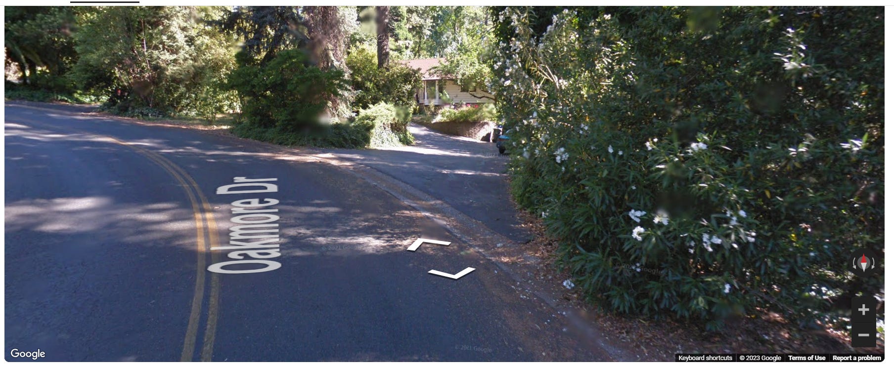
Using Street View, we can see what this land on Oakmore Drive looked like, 6 years ago, before the “campfire” (←please say it out loud using air quotes):

and we can see other homes on Oakmore:
It was a nice, peaceful street with tons of trees:

Here’s another listing for land, the address is 5270 Edgewood Lane:

And here’s Street View for the same address:

Now that we are done recapping Part 1, let’s move on…
BLACK OPS PROGRAM: ERUPT YELLOWSTONE SUPER VOLCANO
As if the people of California haven’t been put through enough hell, there is pretty suspicious evidence that, starting in 2012, a Black Ops (military) program began toying with erupting the Yellowstone Volcano. Here’s a 1-minute must-see clip. The full-length video is in the Sources section below::
Then, starting in late 2022, the media started pumping out content about the possibility of the volcano erupting:

As the media typically does with topics of this nature, they will publish articles saying “Yes, it very well could erupt!” and “No, it will never ever erupt! You are safe!”, which leaves the reader unsure but fearing the worst… imagine if the reader knew about the video I showed you above.

So, not only do the innocent people of Cali have to deal with Directed Energy Weapons, Land Grabs, Tupac’s death and the possibility of their own government erupting their volcano, there’s some new, very questionable things taking place that nobody is talking about and nobody has assigned a name to, so I will call it Operation Break Shasta Dam (and, if you want, we can also add in “and Erupt Mount Shasta Volcano”)
Before we take a trip to Shasta Dam together, click it like you mean it, don’t let me down:
OPERATION BREAK SHASTA DAM
Shasta dam is one of the tallest in the world. This 602-foot-high concrete gravity dam forms California’s largest storage reservoir, Shasta Lake.《Insert redneck voice, “it’s so purdy”》


It’s safe to say that this dam is a damn big deal, especially for the people of Cali.
It just so happened that, while I was writing about Operation Erupt Yellowstone and terrifying FEMA Fault Line Break drills (which will be my next Substack post, Part 3 of this series, which will be a total bombshell), a friend sent me this two-minute video:
As the man in the video points out, this is American airspace... not only is it US air space, but it’s one of the world’s tallest dams, FFS! This makes it an area of National Security interest, which makes it highly concerning that German military was, at a minimum, allowed to come into our air space and fly directly over the entire dam, looping around like Dale Earnhardt on a NASCAR track. On the other hand, it’s even more sketchy if they were invited in by our military. Either way, the manufacturers website for this specific plane specifies that this is part of a specialized 15-plane fleet that is constructed from the latest technology and includes payload mounting under the wings.

I think we can agree, this skin-crawling-creepy. Like, this German military plane flew all the way from The Land of the Schnitzel to come loop around over our tallest-ever dam? Make it make sense.
To add to the mix, a very suspicious chain of events has occurred in Shasta over the past couple years that sure looks like something is in the works here:
2017: The government began disaster planning to develop inundation maps and emergency action plans. An inundation map shows flooding that could result from a dam break or equipment failure.
Now we get into the crazy 2023 timeline. Look how fast all these things happen:
Beginning in February 2023: Severe winter storms, straight-line winds, flooding, landslides, and mudslides hit the area, all at once because, yeah, that’s totally normal Mother Nature (I rolled my eyes while typing that).
March 2023: The EPA seizes control of ALL WATER in the USA, INCLUDING DAMS. They made sure dams were added to the list.
Also in March 2023: Governor Gavin Newsom filed a major disaster declaration for the out-of-control weather chaos. FEMA steps in to help. If you don’t understand how horrifying FEMA is, please read my posts FEMA, GEOENGINEERING, Shocking Army Documents and Emergency Powers and Gov Predicts Population Drop to 100 Million in 2025 +Walmart FEMA Camps +15 Minute Cities. It’s really important to thoroughly understand that this is not an organization who simply helps people. I will be dropping another absolute bombshell article about FEMA within a month. As a teaser, they have been running drills to round up and detain a half-million people at once. So if you haven’t already:
April 2023: Weeks later, FEMA revised the flood zones, specifically for Shasta County. FEMA flood zones are now expanded, which means, under the March 2023 EPA expansion court ruling, they are under control of the EPA. I believe, based on my reading of the new EPA ruling, Lake Shasta and all surrounding areas are in control of the EPA.
June 2023: This one shocked me. I accidentally stumbled across a government document that reveals what will happen if (when) the Shasta dam breaks:

That wasn’t the shocking part. What worried me was that this government document was just created in June 2023. We know that because the one-and-only WayBackMachine screenshot of this page was June 6th.

September 2023: Shasta, who is also home to a volcano called Mount Shasta, gets hit by two large earthquakes.

In fact, Shasta has had 144 earthquakes in the past year

According to this graph on USGS.gov, there really weren’t that many earthquakes in Shasta, until 2014, which is right around the same time Project Erupt Yellowstone began (2012). Although Yellowstone is 900 miles from Shasta, the similarities are uncanny:

And now there’s almost 150 earthquakes in a YEAR in Shasta. Oh, and, when the two large earthquakes happened (September 2023), NBC and other news outlets suddenly promoting content like this, “Are you prepared for the next big one?”:

In Part 3 we will be discussing the 2022 FEMA Fault Line Exercise… and when I say Exercise I’m not referring to a hot blonde in spandex leggings doing pelvic thrusts on a yoga ball. Read Part 3 Now.

NEXT READ:

SOURCES:
Full video, Erupt Yellowstone:
https://www.shastacounty.gov/public-works/page/fema-floodplain-update
https://www.redding.com/story/news/2019/11/22/shasta-county-dam-extreme-peril-rainbow-lake-spillway-failure-cottonwood-creek/4265646002/
https://www.nbcbayarea.com/news/local/earthquakes/earthquake-shasta-county/3313406/
https://twitter.com/Sarah_Cees/status/1704936299680219522
https://map1.msc.fema.gov/data/06/L/19-09-0032P-060358.pdf?LOC=4e245edc7122db47beceef3ebf09fb27
https://floodfind.com/california-flood-maps/
This all sounds like a Hollywood blockbuster movie plot to prepare Californians for this type of disaster and spread huge amounts of fear in the population. It's not like it hasn't been done before by Hollywood. Art imitating life.
I wish that all of the sub-human slime behind this murderous, unadulterated evil had one collective neck and my hands were around it. I can dream, can't I?